Search a Parcel, Read the Record & Use the Map
Find a Licking County property by owner name, street address or Auditor PIN, then use the parcel record to check ownership, values, land and building facts, tax information, transfer history and the correct map location.
This guide explains exactly what to type, what the search fields mean, why a parcel may not appear, how to create a property map or report, and whether your next call belongs to the Auditor, Treasurer, Recorder, GIS team, Archives or Board of Revision.
Quick answer: start with OnTrac, then use the map
Use OnTrac for the main property and tax lookup. Use the Licking County Tax Parcel Viewer when you need map context, a property-map report, aerial orientation, buffer tools or a search by owner, address or Auditor PIN. Copy the PIN before moving to tax-payment, deed, transfer or value-review work.
20 S. Second St., Newark
After understanding the workflow above, open the official OnTrac route for property and tax details or the Tax Parcel Viewer for map-based research.
Choose the exact property task
This page is organized around actions rather than a directory of county links.
Which Licking County property tool do you need?
Begin with the Auditor’s property system to identify the parcel. Then use the office that controls the record or action you need.
Your task |
Use |
What it provides |
Important limit |
|---|---|---|---|
Find owner, address, PIN or property details |
OnTrac |
Property and tax records linked by both the Auditor and Treasurer. |
The owner field is not a substitute for the recorded deed. |
View a parcel map or create a report |
Tax Parcel Viewer |
Owner, address and PIN search, map layers, measurement, buffers and reports. |
GIS lines and measurements are not a legal survey. |
Check or pay property taxes |
Treasurer |
Real-estate tax collection, payment and account help. |
The Auditor values property but does not process tax payments. |
Find a deed, mortgage, lien or release |
Recorder |
Recorded documents, document images, indexes and recording services. |
The online index is not a title opinion or ownership guarantee. |
Transfer, split, merge or exempt a parcel |
Auditor transfer desk |
Conveyance, exempt, split and merge processing. |
Same-day processing has a 4:00 p.m. cutoff. |
Challenge market value |
Auditor / Board of Revision |
Current complaint form, evidence review and hearing process. |
A value complaint does not directly remove a tax levy or special assessment. |
Find older deeds or tax records |
Records & Archives |
Historical county record collections not always available in modern portals. |
Recent or certified records remain with the originating office. |
Search by owner name, address or Auditor PIN
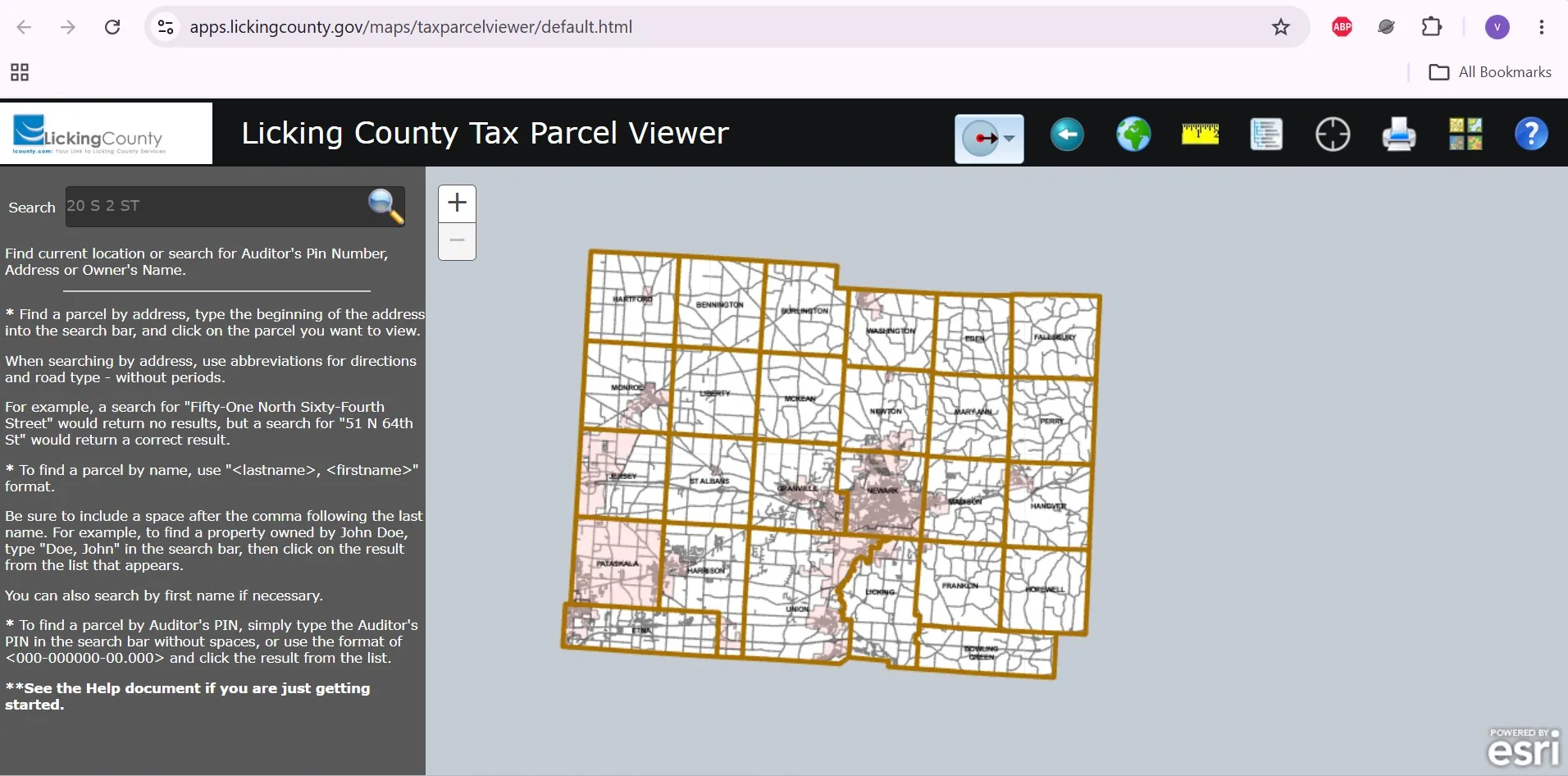
The Tax Parcel Viewer publishes specific formatting instructions. Follow them before assuming the parcel is missing.
- Enter the last name first.
- Add a comma.
- Insert one space after the comma.
- Add the first name.
- Select the correct parcel from the result list.
- Type the beginning of the address.
- Use numeric house numbers.
- Abbreviate directions such as N, S, E or W.
- Abbreviate the road type without periods.
- Choose the correct parcel from the suggestions.
- Copy the PIN from a bill or property record.
- Enter it without spaces.
- Or use the full formatted PIN.
- Select the matching result.
- Verify the property address before continuing.
Micro steps inside the Tax Parcel Viewer
Save these details from the matching parcel
After learning the exact search format, use the live viewer. The map also includes reset, measurement, legend, location, basemap, report and download controls.
No property result found? Try these fixes
Prepare this information before calling
Understand the Licking County property record
Licking County’s parcel services contain ownership, location, value, land-use and map fields. Use each field as a research clue, then move to the controlling record when legal proof is needed.
Field |
What it helps you understand |
Best next action |
|---|---|---|
Auditor PIN |
The parcel identifier used by the Auditor’s property system. |
Copy it before calling, paying, mapping or researching deeds. |
Owner name |
The ownership name currently joined to the public parcel data. |
Use the Recorder’s deed when legal ownership proof is needed. |
Site address |
The physical address associated with the parcel. |
Do not confuse it with the owner’s mailing address. |
Jurisdiction, municipality and township |
The local governmental areas associated with the parcel. |
Use these fields when zoning, service or boundary questions arise. |
Tax district |
The parcel’s local tax-area combination. |
Compare taxes only with parcels in the same or a similar tax district. |
School district |
The school district attached to the parcel record. |
Check it before comparing tax bills with a nearby property. |
Tax, CAUV and GIS acres |
Different acreage fields can serve appraisal, agricultural and mapping purposes. |
Use the recorded deed or survey for legal acreage and dimensions. |
Market land value |
The market value assigned to the land portion. |
Review land use, acreage, neighborhood and CAUV status. |
Market improvement value |
The value assigned to buildings and other taxable improvements. |
Check year built, living area, condition and outbuildings. |
Net total value |
A value field reflecting applicable record adjustments. |
Review exemptions, abatements, Homestead or other status fields. |
Legal description |
A short description or clue associated with the parcel. |
Use the full recorded deed, plat or survey for legal work. |
Plat book/page or instrument |
References that can lead to a recorded plat or document. |
Search the Recorder’s index using the instrument or party names. |
Why one PIN may contain several tracts
Licking County’s parcel-service description says one Auditor parcel number can contain more than one described tract or platted lot. Do not assume each tract has a separate transferable PIN.
Why one tract may have several parcel records
A single described tract or platted lot that crosses more than one taxing district can be represented by multiple split-listed parcels. The county states that split-listed parcels cannot be transferred independently.
Check these physical facts before disputing value
Create a property map and use GIS safely
Create a parcel report or property map
Use buffer, measure, basemap and download tools
Viewer tool |
Useful purpose |
Important caution |
|---|---|---|
Buffer |
Shows parcels or features within a chosen distance. |
A buffer is a research aid, not a legal setback or notice boundary. |
Measure |
Provides approximate map distance or area. |
Do not use it to locate a fence, easement or building line. |
Legend |
Explains visible symbols and map layers. |
Turn on only the layers needed for the current task. |
Locate |
Helps orient the map around the user’s current device location. |
Device location may not be survey-grade. |
Switch Basemap |
Changes the map background for road or aerial context. |
Imagery may have been captured on an earlier date. |
Download Reports and Maps |
Saves available property or survey information and map outputs. |
Confirm that the selected parcel is correct before downloading. |
CSV result download |
Exports affected parcel-list information for structured review. |
Verify live parcel records before taking financial or legal action. |
GIS download facts
The county says it has converted more than 93,000 parcel records and cannot guarantee that every converted item is error-free.
Download data uses Ohio State Plane South, NAD 83, with units represented in feet.
Core downloadable boundary, parcel and road files were listed with July 7, 2026 revisions when verified.
Use the GIS download page only after understanding its coordinate system, revision dates and legal limits. It provides parcel, municipal-boundary, road-centerline, road-right-of-way and township-area downloads.
Check tax information without confusing value and payment
The Treasurer collects real-estate taxes, manufactured-home taxes, estate taxes, hotel and motel taxes and special assessments. The Auditor determines property values and certifies tax rates, but the Treasurer handles collection and payment-account questions.
Micro steps before paying property taxes
If the tax bill looks unexpectedly high
Monday–Friday, 8:30 a.m.–4:30 p.m.; closed on holidays.
After checking the PIN, balance, escrow and current due date, use the county’s official payment application or contact the Treasurer for payment-account help.
Find deeds, mortgages, releases and liens
Use the Recorder when you need the recorded document itself. OnTrac and the parcel map can help identify the PIN, owner, legal-description clue or instrument reference, but the Recorder controls the land-record index and document images.
Search the Recorder step by step
Recorder coverage and office access
Record need |
Official detail |
Practical action |
|---|---|---|
Modern online documents |
The Recorder says online document access includes records from September 22, 1997 forward. |
Start with the current PaxWorld public search. |
Older land records |
The Recorder’s office record books date to the early 1800s. |
Visit or call the Recorder and Records & Archives offices. |
Recording a document |
Office hours are 8:00 a.m.–4:30 p.m.; recording hours are 8:30 a.m.–4:15 p.m. |
Do not arrive near the recording cutoff with a time-sensitive document. |
Standard recording fees |
A $5 preservation surcharge per standard document began January 1, 2025. |
Check the live fee table before preparing payment. |
Fraud monitoring |
The current public system promotes real-estate transfer alerts through AlertMe. |
Register common name variations you want monitored. |
Handle transfers, exempts, splits and merges
Prepare before visiting the transfer desk
Understand the office sequence
Check an incorrect value before filing a complaint
The Auditor is responsible for determining property values for taxing purposes and serves as secretary to the Board of Revision. A useful value challenge begins with a factual or market-based reason—not only the final tax amount.
Review these facts first
Prepare useful evidence
- Recent arm’s-length purchase
- Independent appraisal
- Similar recent sales
- Income information for applicable property
- Current photographs
- Repair estimates
- Structural reports
- Fire, flood or damage records
- Measurements
- Demolition or permit records
- Deed or survey
- Proof of incorrect property use
Board of Revision workflow
Check owner occupancy, Homestead and CAUV
The Auditor administers property-tax reduction programs. Check the parcel’s current status before assuming a missing credit is a valuation error.
Program |
Main purpose |
Useful eligibility clue |
What to verify |
|---|---|---|---|
Owner occupancy |
Reduction connected with a qualifying owner-occupied primary residence. |
The home is the owner’s principal residence rather than a rental or second home. |
Current owner, occupancy date and whether the credit appears in the parcel data. |
Homestead exemption |
Additional relief for qualifying homeowners under Ohio eligibility categories. |
Age, disability, veteran, surviving-spouse, income and residence requirements can apply. |
Current form, supporting documents and continuing eligibility. |
CAUV |
Values qualifying agricultural land according to agricultural use. |
Commercial agricultural use, acreage or income requirements and prior-use history. |
Initial filing, annual renewal, land-use records and possible recoupment. |
Exempt or abated value |
Reflects a qualifying exemption or abatement in the parcel data. |
Program-specific ownership, use and approval rules. |
Effective years, expiration, transfer effect and applicable value fields. |
Before contacting the Auditor
Find historical Licking County property records
Modern OnTrac and Recorder systems do not contain every historical record in the same interface. Licking County Records & Archives publishes separate holdings created by the Auditor and Recorder.
Collection |
Published years |
Where to start |
|---|---|---|
Auditor duplicate tax lists |
1834–1944 |
Records & Archives Auditor holdings. |
Auditor tax roll |
1840 |
Ask Archives about access and indexing. |
Board of Revision or complaint records |
Selected holdings from 1900–1918 |
Use Archives for historical material; use Auditor for recent or certified records. |
Historical deeds |
1803–1918 |
Recorder or Records & Archives depending on the record and copy needed. |
Historical mortgages |
1851–1941 |
Recorder or Archives with party names and approximate date. |
Prepare for an archive request
20 South Second Street
Newark, OH 43055
Contact the Auditor or Recorder directly for recent or certified records.
Licking County property contacts and hours
Office |
Use it for |
Phone |
Hours and address |
|---|---|---|---|
Auditor |
Property records, values, tax rates, transfers, splits, merges, reductions and Board of Revision. |
20 S. Second St., Newark, OH 43055. Monday–Friday, 8:30 a.m.–4:30 p.m. |
|
Treasurer |
Real-estate tax collection, payment, balances, special assessments and account questions. |
20 S. Second St., Newark, OH 43055. Monday–Friday, 8:30 a.m.–4:30 p.m. |
|
Recorder |
Deeds, mortgages, liens, releases, plats, document images and certified-copy questions. |
20 S. Second St., Newark, OH 43055. Office 8:00 a.m.–4:30 p.m.; recording 8:30 a.m.–4:15 p.m. |
|
Records & Archives |
Older Auditor and Recorder record collections. |
20 S. Second St., Newark, OH 43055. Confirm access before visiting. |
|
County Administration |
General county-office routing when the correct department is unclear. |
Donald D. Hill County Administration Building, 20 S. Second St. |
Bring or include these details
Could the parcel be recorded in a neighboring county?
Mailing cities, ZIP codes and roads near county lines can make the correct county unclear. Check nearby Auditor systems when the property does not appear after using the correct Licking County search format.
Useful for properties near the western Licking County boundary and Columbus-area mailing addresses.
Franklin County property search guideUseful for parcels near the southwestern boundary and Pickerington or Baltimore-area records.
Fairfield County property search guideUseful for properties near the northern county boundary.
Knox County property search guideUseful for parcels near the eastern boundary and Zanesville-area mailing routes.
Muskingum County property search guideWhat the online property record cannot prove
- Finding the Auditor PIN
- Reviewing owner and address information
- Checking values and property characteristics
- Identifying tax and school districts
- Locating deed, plat and map clues
- Legal ownership or marketable title
- Exact property boundaries
- Building, zoning or setback approval
- Unreleased liens or easements
- Purchase, lending or legal decisions
Licking County property search FAQs
What is the official Licking County Auditor property search?
OnTrac is the property and tax search linked by the Licking County Auditor and Treasurer. Use it to identify a parcel, review property information and check tax-related records. The Tax Parcel Viewer is the better companion tool when you need map context.
How do I search Licking County property records by owner name?
In the Tax Parcel Viewer, use last name, comma, space, first name format, such as Doe, John. Start with the surname when spelling or ownership wording is uncertain.
How should I enter a Licking County property address?
Enter the beginning of the address and abbreviate directions and street types without periods. The county gives 51 N 64th St as an example of a useful format.
How do I search using a Licking County Auditor PIN?
Enter the Auditor PIN without spaces or use the complete formatted style 000-000000-00.000. Save the PIN because it is the most useful identifier when contacting county offices.
Why will the Licking County parcel report not open?
The Tax Parcel Viewer warns that popup blockers can prevent a parcel report from loading. Allow popups for the official county viewer and create the report again.
Why can one property have more than one Licking County parcel?
One described tract can cross taxing districts and be represented by multiple split-listed parcels. Conversely, one Auditor parcel number may contain more than one described tract or platted lot. Split-listed parcels cannot necessarily be transferred independently.
Are Licking County GIS parcel lines legally exact?
No. The county says GIS maps and data are for reference and are not an official land survey or property description. Use recorded deeds, plats and a professional survey when exact boundaries matter.
Who handles Licking County property-tax payments?
The Licking County Treasurer handles real-estate tax collection, payment and account questions. Call 740-670-5010 and prepare the Auditor PIN, property address and owner name.
Where can I search Licking County deeds and mortgages?
Use the Licking County Recorder’s public records system. Online document access includes many records from September 22, 1997 forward, while older records and indexes are available through the Recorder and Records and Archives offices.
How do I challenge a Licking County property value?
Review the parcel facts, sale history and comparable properties first. Then contact the Auditor about the current Board of Revision process and DTE 1 complaint form. Prepare evidence such as a recent arm’s-length sale, appraisal, photographs, repair estimates or proof of incorrect property characteristics.

Khushboo Bobade is the editor and digital publisher of CountyAuditors.org. She oversees the research and editorial process for the website, ensuring that information about county auditor offices, property records, and government resources is accurate, verified, and easy for visitors to understand.
10 Ohio Property Tax Calculators & Auditor Tools
Built specifically for Ohio's 35% assessment ratio, current DTE forms, and 2026 Homestead, Owner-Occupancy, CAUV, Conveyance Fee, and Board of Revision rules. Every number reflects verified Ohio Department of Taxation amounts.
Annual Tax Bill Estimator
OHIOApplies Ohio's 35% assessment ratio plus your county's effective millage tier — the actual math your auditor uses.
Homestead Reduction Calculator
DTE 105A2026 Ohio Homestead: $29,000 general or $58,000 enhanced (100% disabled vet, KIA spouse). OAGI under $41,000 required for non-veteran applicants.
Owner-Occupancy & Non-Business Credits
DTE 105CEvery Ohio owner-occupied home qualifies for the 2.5% Owner-Occupancy Credit plus the automatic 10% Non-Business Credit. Most owners don't realize these stack.
Conveyance Fee Calculator
ORC 322When you sell or transfer Ohio property, the auditor collects $1 state + up to $3 county per $1,000, plus $0.50 per parcel. Counties choose their rate.
CAUV Agricultural Savings
DTE 109Ohio's Current Agricultural Use Value cuts taxable value dramatically for farmland (10+ acres, or smaller with $2,500+ annual gross income).
Mill Rate Converter
Ohio tax rates appear three ways on auditor sites: mills, percent, or dollars per $1,000. Convert between them instantly.
Parcel Number Cleaner
Ohio's 88 counties each format parcels differently — Franklin uses 010-123456-00, Cuyahoga uses 001-23-456, Hamilton uses 100-0001-0001-00. Auto-detects.
35% Ratio Sanity Check
Ohio law sets taxable value at 35% of market value. If yours is significantly higher, you're a strong BOR appeal candidate.
BOR Appeal Savings
DTE 1A successful Board of Revision complaint typically cuts your value 10–20%. Filing is free and stays in effect until the next reappraisal.
BOR Deadline Countdown
MAR 31Ohio's statutory Board of Revision filing deadline is March 31 for the prior tax year. Miss it and you wait until next year — no extensions.
Verify with the official Ohio source
These calculators use the verified 2026 Ohio Department of Taxation amounts and statutory rules. For your exact bill, exemption status, and county-specific deadlines, always confirm with your county auditor and the Ohio Revised Code:
Estimates use Ohio's 35% statutory assessment ratio and effective tax rate tiers averaged across major Ohio counties. Your actual bill depends on local school levies, voted millage, inside vs. outside millage splits, House Bill 920 reduction factors (HB 920), and special assessments. The 2026 Homestead general amount ($29,000) and enhanced amount ($58,000) reflect HB 187 inflation indexing — your county auditor's office may show slightly different transitional figures. Nothing here is legal or tax advice. CountyAuditors.org is an independent informational directory, not affiliated with any county government.