Find Parcels, Taxes, Maps & Transfer Alerts
Search Mahoning County property records by owner name, street address or parcel number, then use the detailed record to review values, legal-description clues, residential or commercial characteristics, sales, taxes, payments and special assessments.
This guide explains exactly what to type, how to fix a failed lookup, which record section answers each question, when to switch to GIS or Recorder records, and how to handle ownership alerts, tax payment, exemptions, property damage, transfers or a value complaint.
Quick answer: where should you search?
Use the official Mahoning County Auditor search for owner, address, parcel, valuation, land, building, sale and tax information. Start with one search field, open the correct parcel, save the parcel number, and use the record’s Valuation, Legal, Residential, Agricultural, Commercial, Sales, Land, Improvements, Tax, Tax Payments, Tax Distributions and Special Assessments sections.
Fax: 330-480-7571
1st Floor
Youngstown, OH 44503
Monday–Friday, 8:00 a.m.–4:30 p.m.
Deeds and manufactured homes are transferred daily until 3:00 p.m.
After reviewing the short workflow above, open the official search. Use Advanced Search only when a single owner, address or parcel search does not meet the task.
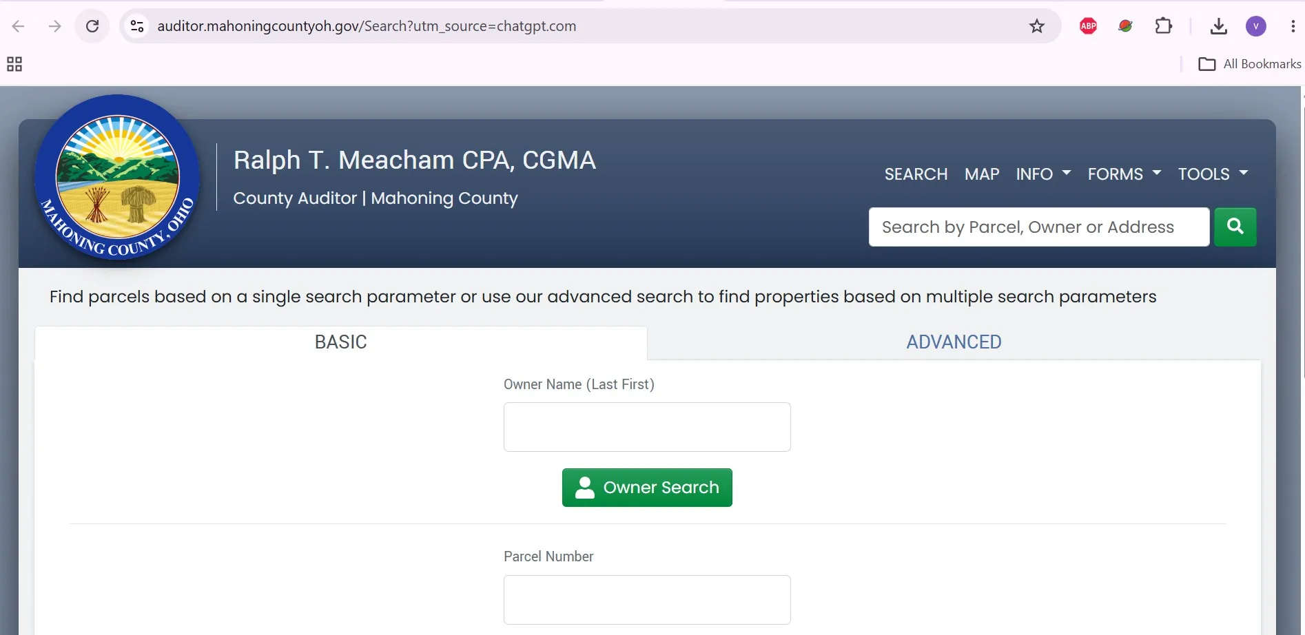
Choose the property task you need to complete
This guide is arranged around actions—not a generic collection of county links.
Which Mahoning County office handles your question?
Your task |
Correct office or tool |
What it provides |
Important limit |
|---|---|---|---|
Find owner, address, parcel or appraised value |
Auditor property search |
Property identity, valuation, characteristics, sales and tax information. |
Owner display is not a title opinion. |
Search sales or groups of properties |
Auditor Advanced Search |
Sale, location, acreage, year-built, living-area and room filters. |
Too many filters can exclude valid results. |
Locate the parcel on a map |
Mahoning County GIS |
Parcel-map context, layers, aerials, tax maps and geographic data. |
Boundaries are approximate and not survey-grade. |
Pay tax or confirm payment |
County Treasurer |
Payment portal, phone payment, tax-bill help and installment programs. |
The Auditor calculates taxes but does not collect them. |
Find a deed, mortgage or lien |
County Recorder |
Recorded land documents and electronic indexes. |
Recorder employees do not perform title searches or give legal advice. |
Challenge appraised value |
Board of Revision |
Formal value-complaint and hearing process. |
It does not decide ordinary tax-rate complaints. |
Apply for a reduction or agricultural valuation |
Auditor forms and information |
Homestead, owner occupancy, CAUV, damage and exemption forms. |
Each program has separate eligibility and deadlines. |
Transfer, split or combine property |
Auditor, GIS and Recorder workflow |
Conveyance forms, GIS preapproval, deed transfer and recording. |
A parcel search is not deed preparation. |
Search by owner, address or parcel number
Mahoning County allows a single-parameter search or a more detailed Advanced Search. Start with one clean identifier before adding filters.
- Enter the owner as last name, then first name.
- Begin with the last name only.
- Add the first name if results are too broad.
- Remove middle initials, punctuation and suffixes if nothing appears.
- Try a trust, LLC, estate or previous owner when appropriate.
- Enter the house number.
- Add the main street name.
- Leave direction and street type blank initially.
- Add North, South, Road or Avenue only when needed.
- Verify the city, township and school district after opening the record.
- Copy the number from a bill, deed or prior property card.
- Enter the full number exactly as shown.
- Keep dashes and the decimal point where required.
- Check zero-versus-letter-O errors.
- Match the address before relying on the result.
Open and verify the correct property
Use Advanced Search only for research
Filter group |
Available criteria |
Useful for |
|---|---|---|
Sales |
Sale-date range, sale-price range, buyer, seller and valid-sale status. |
Comparable-sales or recent-transfer research. |
Location |
Tax districts, townships, municipalities, school districts and neighborhoods. |
Targeting a specific jurisdiction or market area. |
Land |
Property class and acreage range. |
Vacant, agricultural or large-acreage research. |
Residential |
Year built, living area, bedrooms, full baths and half baths. |
Finding physically similar residential properties. |
No Mahoning County property result found?
Prepare this information before calling
Understand every important record section
Section |
What it contains |
Practical next step |
|---|---|---|
Location |
Property location and map access. |
Use it to verify the correct parcel before researching values or taxes. |
Deeded Owner Address |
Address connected with the latest ownership document. |
Do not confuse it with the property’s physical address. |
Taxpayer Address |
Address where county tax correspondence is mailed. |
Use the address-change process when correspondence is going to the wrong place. |
Valuation |
Historical 100% appraised value and 35% taxable value. |
Compare years before assuming a value changed incorrectly. |
Legal |
Legal-description and parcel-reference information. |
Use the recorded deed for complete legal-description work. |
Residential |
Year built, rooms, bedrooms, baths, living area, grade, condition and building features. |
Report material factual errors with documentation. |
Additions |
Attached non-living-area features and appraised amounts. |
Check decks, porches, garages and other additions. |
Agricultural |
CAUV land-pricing information where applicable. |
Check program status and renewal when values look unexpected. |
Commercial |
Commercial-building appraisal information. |
Use income, expense, lease and appraisal evidence for a commercial value complaint. |
Sales |
Recorded transfers, deed type, buyer, seller, amount and valid-sale status. |
Do not treat every transfer as an arm’s-length sale. |
Land |
Land type, acreage, frontage, depth, rate and market value. |
Use a survey or deed for legal dimensions. |
Improvements |
Detached garages, outbuildings and other improvements. |
Check size, condition and year built. |
Tax |
Charges, reductions, credits, special assessments, penalties and amount due. |
Use the Treasurer for payment or payoff questions. |
Tax Payments |
Payment dates, amounts, cycles and receipt numbers. |
Check whether a lender or prior owner already paid. |
Tax Distributions |
Where the parcel’s property tax is distributed. |
Use it to understand school, municipal and county shares. |
Special Assessments |
Project-specific charges separate from ordinary tax. |
Contact the responsible project or collection office when details are unclear. |
Print a useful property-record card
Read values, sales and tax details correctly
Payable during calendar year 2026.
Taxes collected in 2024.
Taxes collected in 2027.
Why values can change without construction
A reappraisal or triennial update studies market conditions and valid sales. A value can also change because of new construction, demolition, Board of Revision action, parcel splits, plats or corrected property facts.
How to evaluate a sale
Read the Tax section line by line
Tax line |
What it means |
Question to ask |
|---|---|---|
Charge |
Gross tax charged before reductions and credits. |
Is the property in the correct tax district? |
Reduction |
Applicable tax reduction factors. |
Did the amount change after a levy or value update? |
Non-Business Credit |
State-authorized credit on qualifying property. |
Does the parcel still qualify? |
Owner Occupancy Credit |
Reduction for a qualifying principal residence. |
Is the owner-occupancy application active? |
Homestead |
Homestead reduction for an approved applicant. |
Was eligibility or income documentation updated? |
CAUV Recoupment |
Prior tax savings charged after loss or withdrawal of CAUV status. |
Was farmland sold, converted or not renewed? |
Special Assessments |
Project or service charges separate from ordinary real-estate tax. |
Which agency placed the assessment? |
Penalty / Interest |
Late-payment or delinquency charges. |
When did the payment post, and is penalty remission available? |
Net Due |
Current database balance after charges, credits and payments. |
Do you need an official payoff from the Treasurer? |
The Auditor’s current estimator is specifically designed for tax year 2025 payable in 2026. Enter an appraised value, select the tax district and property type, then choose applicable owner-occupancy or Homestead reductions.
Check and pay Mahoning County property tax
Micro steps for online payment
Method |
How it works |
Practical warning |
|---|---|---|
Online |
Visa, MasterCard, Discover, electronic check and supported digital wallets. |
Third-party service fee applies. |
Phone |
Call 330-408-6150 for the automated 24/7 system. |
Payment posts the following business day. |
In person |
Treasurer’s Office, 120 Market Street, first floor, Youngstown. |
Office hours are 8:00 a.m.–4:30 p.m., weekdays. |
Mail |
Mail check or money order to Daniel R. Yemma, Treasurer, 120 Market Street, first floor, Youngstown, OH 44503. |
Do not mail cash; retain the canceled check as receipt. |
AutoPay |
Enroll through the payment account for automatic bill payment. |
Keep payment information and account balance current. |
Scheduled payment |
Choose a payment date before the bill due date. |
Adjust the date before the scheduled processing date. |
Tax Installment Plan |
Current taxpayers may pay monthly toward the next half collection. |
Contact the Treasurer to confirm enrollment requirements. |
Use Mahoning County GIS maps correctly
The county’s GIS page reports parcel information updated July 10, 2026. Use the map for parcel location, geographic context and available layers—not as a legal boundary determination.
Micro steps for GIS parcel research
GIS office services and published map fees
Product |
Without aerial image |
With aerial image |
|---|---|---|
8.5 × 11 map |
$1 |
$2 |
11 × 17 map |
$4 |
$6 |
17 × 22 map |
$9 |
$12 |
22 × 34 map |
$16 |
$20 |
34 × 44 map |
$25 |
$35 |
Digital 24 × 36 tax map |
$5 |
Ask GIS when aerial output is required. |
Youngstown, OH 44503
Monday–Friday, 8:00 a.m.–4:30 p.m.
Find deeds, mortgages, liens and older records
Use the Recorder when you need an actual recorded document. The Auditor parcel page helps identify the owner, sale date and parcel, but it does not replace the deed.
Search recorded property documents
Fax: 330-740-2347
1st Floor
Youngstown, OH 44503
Office: 8:00 a.m.–4:30 p.m.
Basement self-service: 8:00 a.m.–4:00 p.m.
Set a Property Ownership Alert correctly
Subscribe to a parcel
Stronger in-person Fraudulent Transfer Prevention alert
Mahoning County also describes an in-person alert intended to notify a qualifying owner before an attempted transfer. It is limited to a home the owner occupies as a principal residence.
Challenge an incorrect property value
The Board of Revision reviews the fair market value of property. It does not decide whether a levy, tax structure, penalty or payment rule is fair.
Check the record before filing
Evidence identified by Mahoning County
Evidence |
Useful detail |
Preparation reminder |
|---|---|---|
Recent sale |
Closing statement, purchase agreement and conveyance statement for a sale within roughly 24 months. |
Prepare a signed, notarized statement when required to show it was arm’s length. |
Certified appraisal |
Professional opinion prepared for tax-valuation purposes. |
Use a value date relevant to the complaint year. |
Condition evidence |
Photographs and professional repair estimates. |
Show how the condition affects market value. |
Construction costs |
Builder-certified costs for newer construction, generally five years old or less. |
Separate land, site and unusual costs where possible. |
Commercial income records |
Leases, rent rolls and up to three years of income and expense statements. |
Organize the information by year and property. |
File and confirm receipt
Find Homestead, owner occupancy, CAUV and damage forms
Form or program |
Use |
Important preparation |
|---|---|---|
DTE 105A |
Homestead application for qualifying seniors, disabled persons and surviving spouses. |
Review current ownership, occupancy, age, disability and income rules. |
DTE 105E |
Certificate of disability for Homestead. |
Obtain the required disability certification. |
DTE 105H |
Income addendum for Homestead. |
Use the correct income year and documentation. |
DTE 105I |
Disabled-veteran and surviving-spouse Homestead application. |
Include required veteran or spouse documentation. |
DTE 105C |
Owner Occupancy Tax Reduction. |
Property must be the qualifying principal residence. |
DTE 26 |
Valuation deduction for destroyed or damaged real property. |
Document the date, cause and extent of damage. |
DTE 23A |
Request remission of late-payment penalties. |
Explain the qualifying reason and include payment evidence. |
DTE 23 |
Real Property Tax Exemption and Remission. |
Check ownership, property use, tax status and filing year. |
CAUV qualification
- Land generally must have been devoted to commercial agricultural use for the prior three years.
- Qualifying activities include crops, livestock, poultry, nursery, timber and other approved uses.
- Each farming unit with identical ownership requires its own application.
- The same agricultural-use requirement applies.
- Average annual gross agricultural income must generally be at least $2,500.
- Anticipated income evidence may be accepted during the initial qualifying period.
CAUV search and renewal checklist
Destroyed or demolished property
If a structure was damaged or destroyed, keep photographs, insurance records, contractor estimates, demolition permits and the date of the event. Taxes are collected one year behind, so a building that existed on January 1 of the tax year may still appear on the current bill.
Transfer, split or combine Mahoning County property
A property transfer may involve the Auditor, GIS and Recorder. Use the correct deed, conveyance form, GIS control documents and current county standards instead of relying on the parcel-search page alone.
Transfer workflow
Mahoning County property contacts, hours and addresses
Office |
Use it for |
Phone |
Address and hours |
|---|---|---|---|
Auditor |
Parcel search, values, tax calculation, forms, CAUV, Homestead, BOR and transfers. |
330-740-2010 Fax: 330-480-7571 |
120 Market St., 1st Floor, Youngstown, OH 44503 8:00 a.m.–4:30 p.m. |
Treasurer |
Tax payment, billing, penalties, posting, AutoPay and installment plans. |
330-740-2460 Fax: 330-740-2142 |
120 Market St., 1st Floor, Youngstown, OH 44503 8:00 a.m.–4:30 p.m. |
Recorder |
Deeds, mortgages, liens, recorded documents and older land records. |
330-740-2345 Fax: 330-740-2347 |
120 Market St., 1st Floor, Youngstown, OH 44503 8:00 a.m.–4:30 p.m. |
GIS |
Parcel viewer, maps, aerials, data, tax maps and training. |
21 W. Boardman St., Youngstown, OH 44503 8:00 a.m.–4:30 p.m. |
|
New address help |
Contact the local zoning office; areas without zoning may contact Emergency Management. |
Use only when the local jurisdiction does not issue the address. |
Bring or include these details
Could the property be recorded in a neighboring county?
Mailing addresses and border roads can cause users to search the wrong county. Use these guides only when the property may sit outside Mahoning County.
Useful for parcels near northern Mahoning County and the Youngstown–Warren area.
Trumbull County property search guideUseful for properties near southern and southeastern Mahoning County.
Columbiana County property search guideUseful for parcels near western Mahoning County or Alliance-area border questions.
Stark County property search guideUseful for properties near northwestern county-border areas.
Portage County property search guideWhat the online property record cannot prove
- Finding a parcel
- Reviewing appraisal facts
- Checking sales and tax history
- Opening map tools
- Preparing office questions
- Legal ownership
- Exact boundaries
- Marketable title
- Official closing payoff
- Legal-description drafting
Mahoning County property search FAQs
How do I search Mahoning County property records by owner name?
Open the official Mahoning County Auditor Advanced Search and enter the owner’s name in last-name-first-name order. Start with the last name only, then add the first name if too many results appear.
Can I search a Mahoning County property using only an address?
Yes. Begin with the house number and main street name. If no result appears, remove the direction, street suffix, punctuation and unit number before searching again.
What should I save after finding a Mahoning County parcel?
Save the parcel number, property address, owner name, appraised value, acreage, legal-description clues, tax district, latest transfer and property-record card.
Why is a recent buyer not shown as the property owner?
A recorded deed and the Auditor’s public parcel display may not update at exactly the same time. Search the former owner, review the Sales section and use the Recorder’s records when legal ownership proof is needed.
Are Mahoning County GIS property lines legally exact?
No. The county states that GIS parcel boundaries are approximate and unsuitable for legal, engineering or surveying purposes. Exact boundaries should be established by an Ohio-registered land surveyor.
What tax year is displayed in the Mahoning County property search?
The Auditor currently states that property values and taxes shown on the website are for tax year 2025, payable in calendar year 2026.
How do I challenge a Mahoning County property value?
Review the parcel facts, gather market-value evidence and file a Board of Revision complaint during the applicable filing period. Tax year 2025 complaints closed March 31, 2026, and tax year 2026 filing begins January 2, 2027.
How does the Mahoning County Property Ownership Alert work?
The free service sends an email after a subscribed parcel transfers. It does not stop a deed transfer or guarantee protection from fraud. The parcel number must be entered with its dashes and decimal point.
Where can I find Mahoning County deeds and mortgages?
Use the Mahoning County Recorder for deeds, mortgages, liens and other recorded land documents. Electronic indexes are available from January 1985 forward, while older records can be viewed at the Recorder’s Office.
What is the Mahoning County Auditor phone number and address?
The Mahoning County Auditor’s phone number is 330-740-2010. The office is at 120 Market Street, first floor, Youngstown, Ohio 44503, and is open Monday through Friday from 8:00 a.m. to 4:30 p.m.

Khushboo Bobade is the editor and digital publisher of CountyAuditors.org. She oversees the research and editorial process for the website, ensuring that information about county auditor offices, property records, and government resources is accurate, verified, and easy for visitors to understand.
10 Ohio Property Tax Calculators & Auditor Tools
Built specifically for Ohio's 35% assessment ratio, current DTE forms, and 2026 Homestead, Owner-Occupancy, CAUV, Conveyance Fee, and Board of Revision rules. Every number reflects verified Ohio Department of Taxation amounts.
Annual Tax Bill Estimator
OHIOApplies Ohio's 35% assessment ratio plus your county's effective millage tier — the actual math your auditor uses.
Homestead Reduction Calculator
DTE 105A2026 Ohio Homestead: $29,000 general or $58,000 enhanced (100% disabled vet, KIA spouse). OAGI under $41,000 required for non-veteran applicants.
Owner-Occupancy & Non-Business Credits
DTE 105CEvery Ohio owner-occupied home qualifies for the 2.5% Owner-Occupancy Credit plus the automatic 10% Non-Business Credit. Most owners don't realize these stack.
Conveyance Fee Calculator
ORC 322When you sell or transfer Ohio property, the auditor collects $1 state + up to $3 county per $1,000, plus $0.50 per parcel. Counties choose their rate.
CAUV Agricultural Savings
DTE 109Ohio's Current Agricultural Use Value cuts taxable value dramatically for farmland (10+ acres, or smaller with $2,500+ annual gross income).
Mill Rate Converter
Ohio tax rates appear three ways on auditor sites: mills, percent, or dollars per $1,000. Convert between them instantly.
Parcel Number Cleaner
Ohio's 88 counties each format parcels differently — Franklin uses 010-123456-00, Cuyahoga uses 001-23-456, Hamilton uses 100-0001-0001-00. Auto-detects.
35% Ratio Sanity Check
Ohio law sets taxable value at 35% of market value. If yours is significantly higher, you're a strong BOR appeal candidate.
BOR Appeal Savings
DTE 1A successful Board of Revision complaint typically cuts your value 10–20%. Filing is free and stays in effect until the next reappraisal.
BOR Deadline Countdown
MAR 31Ohio's statutory Board of Revision filing deadline is March 31 for the prior tax year. Miss it and you wait until next year — no extensions.
Verify with the official Ohio source
These calculators use the verified 2026 Ohio Department of Taxation amounts and statutory rules. For your exact bill, exemption status, and county-specific deadlines, always confirm with your county auditor and the Ohio Revised Code:
Estimates use Ohio's 35% statutory assessment ratio and effective tax rate tiers averaged across major Ohio counties. Your actual bill depends on local school levies, voted millage, inside vs. outside millage splits, House Bill 920 reduction factors (HB 920), and special assessments. The 2026 Homestead general amount ($29,000) and enhanced amount ($58,000) reflect HB 187 inflation indexing — your county auditor's office may show slightly different transitional figures. Nothing here is legal or tax advice. CountyAuditors.org is an independent informational directory, not affiliated with any county government.